The Gulf of Eilat/Aqaba: Where Extremes Meet
The Gulf of Eilat, also known as the Gulf of Aqaba, is a unique location where an arid, red-hued desert meets a deep blue sea teeming with life. It is a place where ancient dark magmatic mountains coexist with young, bright sedimentary rocks, and where a remote periphery intersects with a rich historical and diverse demographic presence.
Here, opposing elements converge and coexist, creating the enchanting contrast that defines the Gulf of Eilat.
The Gulf of Eilat is Israel’s gateway to the tropical Red Sea and the Indian Ocean, offering a small window into a marine ecosystem vastly different from the Mediterranean Sea.
Geological History
The ancient Tethys Sea underwent several cycles of retreat and expansion over this region. Between 55 and 33 million years ago, the Tethys covered what is now Israel, leading to the deposition of sedimentary rock formations.
Geography, Geology, and Geomorphology of the Gulf of Eilat
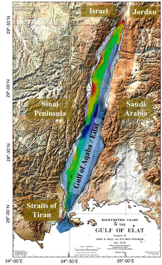
The Gulf of Eilat/Aqaba is a long (180 km) and narrow (15–25 km) marine inlet, forming the northeastern extension of the Red Sea (Gulf of Aqaba). It separates the Arabian Peninsula to the east (Jordan and Saudi Arabia) from the Sinai Peninsula to the west (Israel and Egypt, see Figure 1). The average depth of the gulf is approximately 800 meters, with a maximum depth of 1,850 meters (Figure 2). The southern boundary of the gulf is marked by the Strait of Tiran (approximately 252 meters wide), and it is surrounded by the arid Saharo-Arabian desert belt (Ben-Avraham et al., 1979).
The Gulf of Eilat was formed due to the break-up of the stable Arabian-Nubian massif, which had been tectonically stable since the late Precambrian, over 600 million years ago. Around 20 million years ago, rifting began, first within the Red Sea, separating Africa from Arabia. At its northern extension, the Sinai Peninsula started to separate from Saudi Arabia.
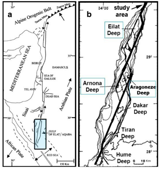
The Gulf of Eilat is the southernmost segment of the Dead Sea Transform fault system, characterized by strike-slip faults and normal faults along its margins. These fault systems have created distinct deep basins on the seafloor, including:
-
The Eilat Deep in the northern basin, reaching 900 meters.
-
The Aragonese Deep in the central basin, with a depth of 1,850 meters, alongside the nearby Arnona Deep (1,550 meters).
-
The southern basin, along the Saudi Arabian coastline, includes two depressions: the Dakar Deep (1,300 meters) and the Tiran Deep (1,300 meters) (Figure 2).
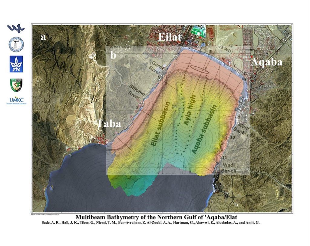
Due to its young geological age and ongoing tectonic activity, the Gulf of Eilat has an exceptionally steep submarine topography. There is virtually no continental shelf, and the seabed descends sharply from the shore, with slopes reaching angles of up to 450° and, in some cases, up to 800°—making this one of the steepest underwater locations on Earth (Ben-Avraham et al., 1979; Shaked et al., 2002; Tibor et al., 2010). The northern part of the gulf is asymmetrical, tilting eastward (Figure 3), with the "Iyla Ridge" separating the Eilat sub-basin to the west from the Aqaba sub-basin to the east (Tibor et al., 2010).
The coastline around the Gulf of Eilat is predominantly rocky and mountainous, characterized by steep, rugged cliffs (Shaked et al., 2002). The surrounding mountains consist of Precambrian plutonic rocks (mainly granite) and metamorphic rocks (schist and gneiss), along with Cretaceous-Eocene sedimentary rock layers that rise up to 1.5 kilometers above sea level (Ben-Avraham et al., 1979). Fossilized coral reefs and exposed marine terraces from the Pleistocene and Holocene periods are found throughout the region. For further details on the geological stratigraphy and rock formations of the Eilat Mountains, see The Eilat Area as a Field School for Geology by Beyth & Calvo (2015).
Studies of fossil coral reefs and beach rocks from the Pleistocene and Holocene suggest that sea level has remained relatively stable over the past 6,000 years, with only minor vertical tectonic movements (Shaked et al., 2002). In some areas, the shoreline has advanced over 100 meters seaward, likely due to sediment transport and deposition processes influenced by mid-Holocene climate shifts (Shaked et al., 2002).
Figures
-
Figure 1. Bathymetry of the Gulf of Eilat/Aqaba. Originally published by Ben-Avraham et al. (1979) and modified by Sade et al. (2008).
-
Figure 2. (a) Tectonic setting of the Dead Sea Rift. (b) The general tectonic structure of the Gulf of Eilat/Aqaba, showing major fault lines and separate basins: Eilat, Aragonese, Arnona, Dakar, and Tiran. Adapted from Tibor et al. (2010).
-
Figure 3. (a) Bathymetry of the northern Gulf of Eilat/Aqaba. Map from Sade et al. (2008). (b) The "Iyla Ridge" (dashed line) separating the "Eilat" sub-basin (west) from the "Aqaba" sub-basin (east), adapted from Tibor et al. (2010).
References
-
Ben-Avraham, Z., Almagor, G., Garfunkel, Z. (1979). Sediments and structure of the Gulf of Elat (Aqaba) – Northern Red Sea. Sediment. Geol. 23 (1), 239-267.
-
Beyth, M., Calvo, R. (2015). The Eilat area as a field school for geology. Report GSI/10/2014. Ministry of National Infrastructures, Energy, and Water Resources, The Geological Survey of Israel. Available at: geology_GSI-10-2015.pdf.
-
Sade, A. R., Hall, J. K., Tibor, G., Niemi, T. M., Ben-Avraham, Z., Al-Zoubi, A. A., Hartman, G., Akawwi, E., Abueladas, A. R., Amit, G. (2008). The Israel national bathymetric survey: Northern Gulf of Aqaba / Eilat Poster. Israel Journal of Earth Sciences, 57, 139-144.
-
Shaked, Y., Marco, S., Lazar, B., Stein, M., Cohen, C., Sass, E., Agnon, A. (2002). Late Holocene shorelines at the Gulf of Aqaba: migrating shorelines under conditions of tectonic and sea level stability. EGU Stephan Mueller Special Publication Series, 2, 105-111.
-
Tibor, G., Niemi, T. M., Ben-Avraham, Z., Al-Zoubi, A., Sade, R. A., Hall, J. K., Hartman, G., Akawi, E., Abueladas, A., Al-Ruzouq, R. (2010). Active tectonic morphology and submarine deformation of the northern Gulf of Eilat/Aqaba from analyses of multibeam data. Geo-Mar. Lett. 30 (6), 561-573.